
Nadir Kapetanović, Anja Babić, Ivan Lončar, Igor Kvasić, Vladimir Slošić, Barbara Arbanas
Members of the IEEE OES University of Zagreb SBC organized a significant number of field trials during Breaking the Surface international interdisciplinary field workshop of maritime robotics and applications that was held in Biograd na Moru, Croatia, during the week of 26 September to 3 October. as well as during the following week. This article brings a short overview of those activities.
HEKTOR project trials
Our SBC members working on the HEKTOR project are in charge of developing the heterogeneous autonomous robotic system in mariculture applications. Mariculture scenarios include an ASV Korkyra (developed by our team), Blueye Pro ROV integrated with the ASV by our team, and a UAV (developed by our colleagues from LARICS team at the University of Zagreb Faculty of Electrical Engineering and Computing). The main objective is to enable autonomous inspection of the fish cages from air, at and below the surface of the sea.
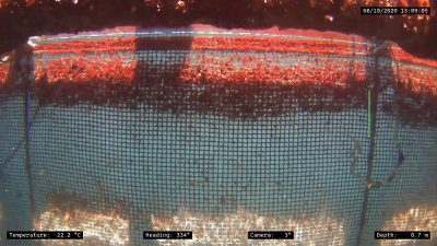
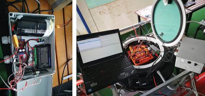
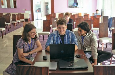
During the BtS 2021 workshop, the performance of vertical rope detection and mission control was tested at the seawater pool in Biograd na Moru, Croatia. A real fish cage net was strung across the pool to emulate a real-world environment, and the ROV was controlled by ROS2 running on a laptop, as shown in the following figure. The performance tests were successful, but the visual detection algorithm should be made even more robust to different lighting conditions, especially early in the morning and at dusk.
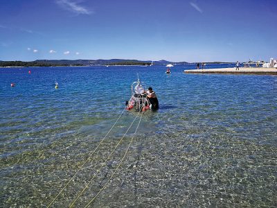
Tying the ASV Korkyra to a pillar at the beach in Biograd na Moru to ensure safety during the thruster power consumption tests
Extensive tests of ASV Korkyra’s power consumption were also performed. Minimum and maximum consumption of each subsystem or device were measured and corrected for the baseline consumption. It shows that the autonomy of the ASV Korkyra ranges from the theoretical worst-case of 3.22h (when all the motors, computers and subsystems are working at full power) to 20.58h in the best case. It is however realistic to conclude that the average expected autonomy would range from 10h to 11h.
Control of the ROV by the ASV needs position feedback. Thus, WaterLinked Underwater GPS (UWGPS) G2 SBL topside system with a bottomside Locator U1 system met all these requirements and was integrated into the ASV Korkyra during the week after the BtS 2021.
Since the integration of the UWGPS G2 with ROS2 was done before BtS 2021, this meant that frame transforms needed to be performed in the post-processing phase taking into account ASV’s known GPS position and orientation in 3D space.
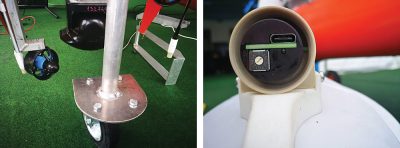
Integration of the ROV onto the ASV and their cooperative path planning in autonomous inspection missions requires a tether management system (TMS) to be developed together with a docking mechanism (DM). During the BtS 2021 workshop, a prototype control box of the TMS was developed. It enables the manual control mode of the TMS motor but also an automatic control mode from the ASV’s main computer over serial communication.
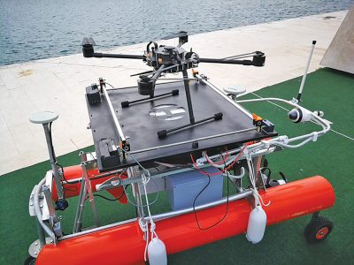
As mentioned earlier, the UAV will perform fish cage inspections from the air. This will be done in coordination with the ASV Korkyra, so a landing platform (LP) is needed for the UAV to be docked onto the ASV. A great number of test runs were performed to detect possible issues with the LP. Extensive testing was first performed in the lab environment. Similar to the TMS, the LP has a control box allowing manual control, but also automatic control over serial communication integrated with ROS. During Breaking the Surface 2021, additional LP robustness tests were performed and were successful. These tests showed that the auto control mode is fully functional together with serial communication integration with ROS1.
Multifunctional smart buoys trials
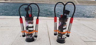
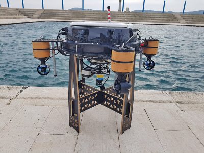
The trials taking place after BTS 2021 were the first field trials for the Multifunctional Smart Buoy project, which started in April 2021. The team working on the project prepared two initial prototypes of the underwater sensor units that communicate with a floating buoy unit, forming a marine system for long-term environmental monitoring.
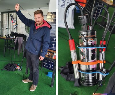
The aim of these initial field trials was to perform full integration of the developed subsystems – Cyclops fluorometer sensors for various water quality measurements, a small acoustic nanomodem for long-range underwater communication, the units’ main electronic boards including an SD-card based logger and a Real Time Clock, as well as a battery assembly composed of lithium-ion cells, all housed within a plexiglass enclosure and equipped with specially-made attachment points for a surface unit’s mooring line.
After integration, two units were vacuum-tested and left to perform an overnight experiment on land, logging their respective sensor data and battery voltage. Once this “test run” was successfully concluded, the units’ batteries were recharged and they were deployed in the seaside pool.
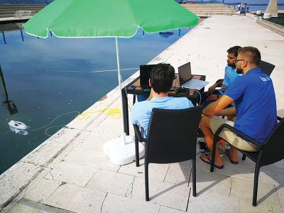
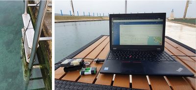
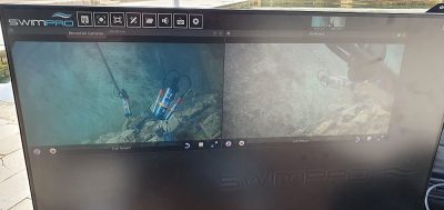
To serve as a surface node and an endpoint for the sensor units’ acoustic packets, a topside laptop was set up with an acoustic modem running into the pool. This laptop collected data sent by the units, parsed it, and sent it to a ThingsBoard IoT dashboard where it was presented in a user-friendly way. All the while, the deployed sensor units were monitored using underwater cameras affixed to the sides of the pool.
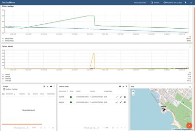
Differences in sensor unit behaviour were analysed each day, especially with regards to energy consumption. For the remaining three days of the field trials, the units were recharged and redeployed underwater with the goal of testing different sleep modes and sleep durations, in order to gather valuable data for ensuring long-term autonomy of the final buoy system, while achieving regular and persistent acoustic communication of all gathered sensor measurements.
The trials after BtS 2021 proved incredibly useful as both data and experience gathered during the first-ever deployment of the developed prototypes lead to excellent insights regarding the current state of the system, as well as extensive and specific plans for future work.
Autonomous multipurpose ship project trials
During and after the Breaking the Surface 2021 workshop, the initial trials for the Autonomous ship project took place. In the project, the plan is to build a multipurpose autonomous ship in collaboration with Brodosplit shipyard. The ship will be a fast response vessel for firefighting and oil recovery. The goal is to mitigate negative impact of maritime accidents on the environment. Since the project was still in the design phase as it started in July 2021, we could only rely on equipment available in LABUST.
The goal of the initial trials was to gather perception data from the maritime environment using a lidar. This data will be useful for testing of developed algorithms used for detection of objects commonly encountered in maritime environment and testing of readily available SLAM algorithms. Since the marina is an environment in which you can only rely on perception data for safe navigation, there is a great benefit on having real data for algorithm validation.
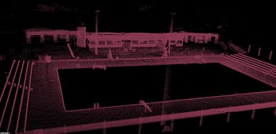
During the trials we integrated the lidar to the Korkyra catamaran vehicle. Lidar was mounted together with a camera to a landing platform used in project HEKTOR. For a test run, we first mounted the sensor rig to a box and pushed it around a seawater pool. Results of the lidar processing can be seen from the image below where a reconstructed map of the pool can be seen.
After the initial test, we set out to the sea to gather more relevant data from a marina in Biograd na Moru. The catamaran was driven manually around a marina with close supervision from a dinghy. The data collected will be used as a testing dataset in future publications.
ADRIATIC project trials
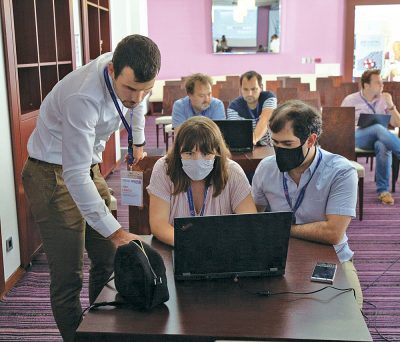
As part of the Breaking the Surface 2021 program, our IEEE OES SBC members held an introduction lecture and a hands-on tutorial in Unity simulator related to the ongoing project ADRIATIC – Advancing Diver-Robot Interaction Capabilities. The project focuses on finding innovative and intuitive ways of interaction between human divers and autonomous underwater vehicles (AUVs). Within the project the collaboration scheme between the diver and the AUV envisions the robot vehicle to take the place of a robotic diving buddy, with the prime goal of observing the diver and determining his physiological parameters such as breathing, hearth and motion rate and to allow the detection of critical diver states and in turn increase safety. One of the project scenarios includes the autonomous underwater vehicle as a diver navigator, where the vehicle uses its advanced localization and navigation capabilities to navigate the diver to a target or point of interest. The participants have had the chance to experience that scenario in a simulated environment using Unity 3D. The tutorial had multiple objectives:
- Showcasing the Unity marine simulator developed within the Laboratory and demonstrating its capabilities
- Evaluating the feasibility of using this type of underwater simulation for developing algorithms and training
- Gathering valuable mission data and feedback from a larger audience of experts from various marine-related fields
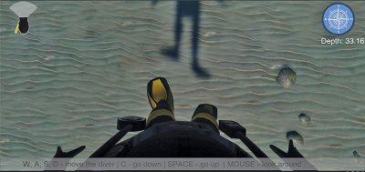
The simulator works as a first person-view game played from a diver’s perspective. The diver is controlled using “WASD” keyboard controls and mouse for movement, plus “C” and “SPACE” keys for diving and ascending when underwater. The task is divided into two separate missions. The mission starts as the dive commences at the diving vessel. The first objective is to navigate the diver underwater using keyboard controls to two separate targets at previously known positions. The first target is a sunken plane and the second is a shipwreck. In the first mission the participants navigate to the position using a diving compass and depth sensor gauge, which is the usual equipment that divers would have at their disposal.
At the dive start, the player is given only the direction and distance towards each target and has to overcome waves, sea currents and low visibility underwater in order to reach the targets. In the second mission the goal is the same, but this time the navigation is aided by the diving robot. The robot uses its simulated proprioceptive navigational sensors to determine its location and positions itself on an imaginary safety circle between the diver and the target, pointing to the waypoint from the divers’ perspective. While the visualization and simulation parts are running in Unity, all the navigation algorithms are running in ROS and are connected to Unity, which generates the simulated sensor readings. At the end of the two missions, participants can view their results in the form of displaying the trajectories in 2D and 3D along with the statistics such as distance traveled and time of each mission. At the end, the participants were given a short output survey to express their feedback and help further develop the simulator. Future plans of the project include analyzing the navigation data and statistics, along with the gathered feedback, and publish the results in a future paper.
ROADMAP project trials
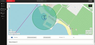
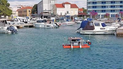
During the trials on BtS 2021, another experiment was performed in the field of underwater localization. Most of the projects that LABUST is involved in demand precise localization of the AUVs. Therefore, a new localization technique – breadcrumb localization- was introduced as an upgrade to the localization algorithms that we already use at LABUST.
The main goal of the experiment was to collect data that will confirm the theoretical background of breadcrumb localization. The experiment was performed in the Olympic seawater swimming pool (dimensions: 50m by 25m). Equipment used:
- autonomous surface vehicle aPad (further in the text – ASV aPad) with mounted underwater acoustic pingers and camera looking downwards
- five underwater acoustic pingers in waterproof casing with anchors
- GPS RTK system for precise navigation and localization
- PC with ROS installed.
When it comes to underwater localization of the AUVs, a common problem regarding proprioceptive sensors, such as IMU, is a drift error that accumulates during time as AUV executes its mission. The idea of the breadcrumb algorithm was to minimize the error of the localization with so-called “breadcrumbs” that are actually underwater acoustic pingers deployed one after another during the mission. ASV aPad (or AUV in a different scenario) can measure the distance between itself and each of the breadcrumbs individually. Those measurements can be used to correct the localization estimate from IMU and other sensors that are mounted on/inside the AUV/ASV.
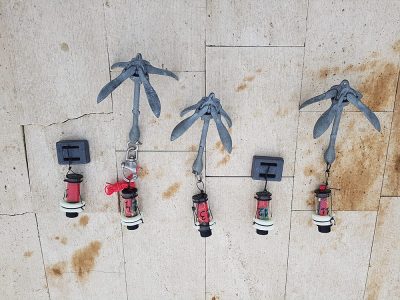
Before the experiment aPad was serviced, all of the needed sensors for experiments were mounted on it. Breadcrumbs housings were made at LABUST out of plexiglass tubes inside of which is the pingers’ electronics and battery.
During the experiment, there has been poor weather conditions that postponed the experiment for some time and caused a lower amount of recorded data. There were also some technical problems with the aPad’s IMU that wasn’t able to calibrate itself. One breadcrumb was replaced because of the seawater penetration inside of the housing due to a defective seal.
The recorded data will be used for the confirmation of the breadcrumb localization theoretical background and some other algorithms that are being developed and tested at the moment at LABUST.
Conclusion
BtS 2021 workshop and the field trials in the following week were a successful demonstration for many of our research projects. It gave us a chance to involve our fellow IEEE OES UNIZG SBC members to participate actively. During the field trials of 5 research projects, various vehicles and subsystems were tested: 2 ASVs, 1 ROV, 1AUV, 1 1UAV, 1 landing platform, 1 TMS, and a 2-node underwater sensor network (UWSN). Several cameras, lidar, environmental sensors, acoustical localization and communication systems, and sonars were used for performance testing of mission planning, navigation guidance and control systems, as well as long-term Internet of underwater things (IoUWT) modules. Furthermore, a transition from real-life into virtual reality (VR) experiments took place to test human-robot interaction (HRI) and robot-aided underwater diver navigation.
We are looking forward to our Spring/Summer field trials and of course yet another edition of Breaking the Surface in Autumn 2022. During this year’s BtS, HEKTOR project is planned to have final experiments of AS-ROV-UAV cooperative fish net pen inspection. BOVE project will have its final experiments as well, testing the long-term environmental monitoring by a UWSN in all configurations defined by the project. For the Autonomous ship project, the plan is to add either virtual or real obstacles in the sea to demonstrate collision avoidance algorithms while autonomously navigating a predefined route. Breadcrumb underwater localization algorithm will be tested in the scope of the ROADMAP project, this time with an AUV and a diver.
 Suleman Mazhar has been working as a professor in Information & Communication Engineering at Harbin Engineering University (China) since July 2019. He did PhD from Tokyo University (Japan) and postdoctorate from Georgetown University (Washington DC, USA). He had BS-CS from FAST-NUCES (Lahore) and MS from GIK Institute (Pakistan). He is TYSP young scientist fellow (Ministry of Science & Technology China) and have won several research grants from international organizations such as DAAD (Germany), ICIMOD (Nepal), NRPU (Higher Education Commission Pakistan), WWF (Worldwide Fund for Nature) Pakistan. His research focus is deep learning and signal processing applications for environmental monitoring, with particular focus on underwater acoustics, and marine mammal conservation. He is a reviewer for professional journals such as Journal of Acoustical Society (America), IEEE Journal of Oceanic Engineering, IEEE Sensors Journal, Applied Acoustics, IEEE Transactions on Intelligent Transportation Systems.
 Peng Ren is a full professor with the College of Oceanography and Space Informatics, China University of Petroleum (East China). He is the director of Qingdao International Research Center for Intelligent Forecast and Detection of Oceanic Catastrophes. He received the K. M. Scott Prize from the University of York, the Natural Science award (first rank) from China Institute of Electronics, and the Eduardo Caianiello Best Student Paper Award from 18th International Conference on Image Analysis and Processing as one co-author. He has served as an associate editor of IEEE Transactions on Geoscience and Remote Sensing.
 Mohd Rizal Arshad is a full professor at the School of Electrical and Electronic Engineering at Universiti Sains Malaysia (USM), Malaysia, where he specializes in ocean robotics technology and intelligent system. He received his B.Eng. in Medical Electronics & Instrumentation and PhD in Electronic Engineering from University of Liverpool, UK in 1994 and 1999, respectively. He completed his MSc. in Electronic Control Engineering from the University of Salford, UK in Dec 1995. He has supervised many postgraduate students and published extensively in local and international publications. He is a senior member of the IEEE, and was awarded IEEE OES Presidential Award in 2019.
 Itzik Klein is an Assistant Professor, heading the Autonomous Navigation and Sensor Fusion Lab, at the Charney School of Marine Sciences, Hatter Department of Marine Technologies, University of Haifa. He is an IEEE Senior Member and a member of the IEEE Journal of Indoor and Seamless Positioning and Navigation (J-ISPIN) Editorial Board. Prior to joining the University of Haifa, he worked at leading companies in Israel on navigation topics for more than 15 years. He has a wide range of experience in navigation systems and sensor fusion from both industry and academic perspectives. His research interests lie in the intersection of artificial intelligence with inertial sensing, sensor fusion, and autonomous underwater vehicles.
 John R. Potter (IEEE M’94, SM’02, F’18) graduated in the previous century with a joint honours Mathematics and Physics Degree from Bristol and a PhD. in Glaciology and Oceanography from Cambridge, UK studying Antarctic ice mass balance, where he spent four consecutive summers. This work helped underscore the non-linear fragility of polar ice to climate change and led to him receiving the Polar Medal from Queen Elizabeth II in 1988.
 Nick is a Visiting Fellow at the UK National Oceanographic Center, Southampton His nomination was endorsed by the Underwater Acoustics Technology Committee. He had worked as a Research Associate and Lecturer at University of Birmingham and has been working as a Research Scientist at the Applied Research Laboratory, University of Texas, Austin. He has also served as a Program Officer at the Office of Naval Research Global. He is a senior member of IEEE (OES) and a Fellow of Acoustical Society of America (ASA). Nick has also been serving as Assoc. Editor for IEEE JoE and JASA. He is widely acknowledged for his expertise are seabed acoustics, parametric array modeling, sonar beamformer, underwater signal processing.
 Maurizio Migliaccio (M’91-SM’00-F’17) is Full professor of Electromagnetics at Università di Napoli Parthenope (Italy) and was Affiliated Full Professor at NOVA Southeastern University, Fort Lauderdale, FL (USA). He has been teaching Microwave Remote Sensing since 1994. He was visiting scientist at Deutsche Forschungsanstalt fur Lüft und Raumfahrt (DLR), Oberpfaffenhofen, Germany. He was member of the Italian Space Agency (ASI) scientific committee. He was member of the ASI CosmoSkyMed second generation panel. He was e-geos AdCom member. He was Italian delegate of the ESA PB-EO board. He was Member of South Africa Expert Review Panel for Space Exploration. He serves as reviewer for the UE, Italian Research Ministry (MIUR), NCST, Kazakhstan and Hong Kong Research board. He lectured in USA, Canada, Brazil, China, Hong Kong, Germany, Spain, Czech Republic, Switzerland and Italy. He was Italian delegate at UE COST SMOS Mode Action. He is listed in the Italian Top Scientists. He is an IEEE Trans. Geoscience and Remote Sensing AE, International Journal of Remote Sensing AE, and was IEEE Journal of Oceanic Engineering AE Special Issue on Radar for Marine and Maritime Remote Sensing, IEEE JSTARS AE of the Special Issue on CosmoSKyMed, Member of the Indian Journal of Radio & Space Physics Editorial board. His main current scientific interests cover SAR sea oil slick and man-made target monitoring, remote sensing for marine and coastal applications, remote sensing for agriculture monitoring, polarimetry, inverse problems for resolution enhancement, reverberating chambers. He published about 160 peer-reviewed journal papers on remote sensing and applied electromagnetics.
 He has developed various types of Autonomous Underwater Vehicles (AUVs) and related application technologies including navigation methods, a new sensing method using a chemical sensor, precise seafloor mapping methods, a precise seabed positioning system with a resolution of a few centimeters, a new sensing system of the thickness of cobalt-rich crust; and more. He has shown, by using these technologies that AUVs are practicable and valuable tools for deep-sea exploration.
 Donna Kocak has had an outstanding career in defense and scientific projects developing and applying solutions in subsea optics, imaging and robotics. She graduated with an M.Sc in Computer Science in 1997 from the University of Central Florida; an MBA in 2008 from the University of Florida; and M.Sc in Industrial Engineering in 2011 from the University of Central Florida. She is currently a Senior Scientist, Advanced Concepts Engineering, and Fellow at the Harris Corporation in Melbourne, Florida, where she has developed novel optical imaging and communication solutions for under-sea defense and scientific projects. Prior to 2008 Donna Kocak was Founder and President of Green Sky Imaging, LLC (GSI) who developed laser/video photogrammetry software for underwater inspection and survey. Her earlier career positions were with Naval Training Systems Center, Florida; Harbor Branch Oceanographic Institution, Florida; eMerge Interactive; and the Advanced Technologies Group in Florida.
 John Potter has a Joint Honours degree in Mathematics and Physics from Bristol University in the UK and a PhD in Glaciology and Oceanography from the University of Cambridge on research in the Antarctic, for which he was awarded the Polar Medal in 1988. John has worked on polar oceanography, underwater acoustics, ambient noise (including imaging), marine mammals, communications, IoUT, autonomous vehicles and strategic development. He has 40 years’ international experience working at the British Antarctic Survey in the UK, NATO in Italy, SIO in California, NUS in Singapore and most recently at NTNU in Norway. John is a Fellow of the IEEE and MTS, an Associate Editor for the IEEE Journal of Oceanic Engineering, IEEE OES Distinguished Lecturer, PADI Master Scuba Diver Trainer & an International Fellow of the Explorer’s Club.
 Dr. James V. Candy is the Chief Scientist for Engineering and former Director of the Center for Advanced Signal & Image Sciences at the University of California, Lawrence Livermore National Laboratory. Dr. Candy received a commission in the USAF in 1967 and was a Systems Engineer/Test Director from 1967 to 1971. He has been a Researcher at the Lawrence Livermore National Laboratory since 1976 holding various positions including that of Project Engineer for Signal Processing and Thrust Area Leader for Signal and Control Engineering. Educationally, he received his B.S.E.E. degree from the University of Cincinnati and his M.S.E. and Ph.D. degrees in Electrical Engineering from the University of Florida, Gainesville. He is a registered Control System Engineer in the state of California. He has been an Adjunct Professor at San Francisco State University, University of Santa Clara, and UC Berkeley, Extension teaching graduate courses in signal and image processing. He is an Adjunct Full-Professor at the University of California, Santa Barbara. Dr. Candy is a Fellow of the IEEE and a Fellow of the Acoustical Society of America (ASA) and elected as a Life Member (Fellow) at the University of Cambridge (Clare Hall College). He is a member of Eta Kappa Nu and Phi Kappa Phi honorary societies. He was elected as a Distinguished Alumnus by the University of Cincinnati. Dr. Candy received the IEEE Distinguished Technical Achievement Award for the “development of model-based signal processing in ocean acoustics.” Dr. Candy was selected as a IEEE Distinguished Lecturer for oceanic signal processing as well as presenting an IEEE tutorial on advanced signal processing available through their video website courses. He was nominated for the prestigious Edward Teller Fellowship at Lawrence Livermore National Laboratory. Dr. Candy was awarded the Interdisciplinary Helmholtz-Rayleigh Silver Medal in Signal Processing/Underwater Acoustics by the Acoustical Society of America for his technical contributions. He has published over 225 journal articles, book chapters, and technical reports as well as written three texts in signal processing, “Signal Processing: the Model-Based Approach,” (McGraw-Hill, 1986), “Signal Processing: the Modern Approach,” (McGraw-Hill, 1988), “Model-Based Signal Processing,” (Wiley/IEEE Press, 2006) and “Bayesian Signal Processing: Classical, Modern and Particle Filtering” (Wiley/IEEE Press, 2009). He was the General Chairman of the inaugural 2006 IEEE Nonlinear Statistical Signal Processing Workshop held at the Corpus Christi College, University of Cambridge. He has presented a variety of short courses and tutorials sponsored by the IEEE and ASA in Applied Signal Processing, Spectral Estimation, Advanced Digital Signal Processing, Applied Model-Based Signal Processing, Applied Acoustical Signal Processing, Model-Based Ocean Acoustic Signal Processing and Bayesian Signal Processing for IEEE Oceanic Engineering Society/ASA. He has also presented short courses in Applied Model-Based Signal Processing for the SPIE Optical Society. He is currently the IEEE Chair of the Technical Committee on “Sonar Signal and Image Processing” and was the Chair of the ASA Technical Committee on “Signal Processing in Acoustics” as well as being an Associate Editor for Signal Processing of ASA (on-line JASAXL). He was recently nominated for the Vice Presidency of the ASA and elected as a member of the Administrative Committee of IEEE OES. His research interests include Bayesian estimation, identification, spatial estimation, signal and image processing, array signal processing, nonlinear signal processing, tomography, sonar/radar processing and biomedical applications.
 Kenneth Foote is a Senior Scientist at the Woods Hole Oceanographic Institution. He received a B.S. in Electrical Engineering from The George Washington University in 1968, and a Ph.D. in Physics from Brown University in 1973. He was an engineer at Raytheon Company, 1968-1974; postdoctoral scholar at Loughborough University of Technology, 1974-1975; research fellow and substitute lecturer at the University of Bergen, 1975-1981. He began working at the Institute of Marine Research, Bergen, in 1979; joined the Woods Hole Oceanographic Institution in 1999. His general area of expertise is in underwater sound scattering, with applications to the quantification of fish, other aquatic organisms, and physical scatterers in the water column and on the seafloor. In developing and transitioning acoustic methods and instruments to operations at sea, he has worked from 77°N to 55°S.
 René Garello, professor at Télécom Bretagne, Fellow IEEE, co-leader of the TOMS (Traitements, Observations et Méthodes Statistiques) research team, in Pôle CID of the UMR CNRS 3192 Lab-STICC.
 Professor Mal Heron is Adjunct Professor in the Marine Geophysical Laboratory at James Cook University in Townsville, Australia, and is CEO of Portmap Remote Ocean Sensing Pty Ltd. His PhD work in Auckland, New Zealand, was on radio-wave probing of the ionosphere, and that is reflected in his early ionospheric papers. He changed research fields to the scattering of HF radio waves from the ocean surface during the 1980s. Through the 1990s his research has broadened into oceanographic phenomena which can be studied by remote sensing, including HF radar and salinity mapping from airborne microwave radiometers . Throughout, there have been one-off papers where he has been involved in solving a problem in a cognate area like medical physics, and paleobiogeography. Occasionally, he has diverted into side-tracks like a burst of papers on the effect of bushfires on radio communications. His present project of the Australian Coastal Ocean Radar Network (ACORN) is about the development of new processing methods and applications of HF radar data to address oceanography problems. He is currently promoting the use of high resolution VHF ocean radars, based on the PortMap high resolution radar.
 Hanu Singh graduated B.S. ECE and Computer Science (1989) from George Mason University and Ph.D. (1995) from MIT/Woods Hole.He led the development and commercialization of the Seabed AUV, nine of which are in operation at other universities and government laboratories around the world. He was technical lead for development and operations for Polar AUVs (Jaguar and Puma) and towed vehicles(Camper and Seasled), and the development and commercialization of the Jetyak ASVs, 18 of which are currently in use. He was involved in the development of UAS for polar and oceanographic applications, and high resolution multi-sensor acoustic and optical mapping with underwater vehicles on over 55 oceanographic cruises in support of physical oceanography, marine archaeology, biology, fisheries, coral reef studies, geology and geophysics and sea-ice studies. He is an accomplished Research Student advisor and has made strong collaborations across the US (including at MIT, SIO, Stanford, Columbia LDEO) and internationally including in the UK, Australia, Canada, Korea, Taiwan, China, Japan, India, Sweden and Norway. Hanu Singh is currently Chair of the IEEE Ocean Engineering Technology Committee on Autonomous Marine Systems with responsibilities that include organizing the biennial IEEE AUV Conference, 2008 onwards. Associate Editor, IEEE Journal of Oceanic Engineering, 2007-2011. Associate editor, Journal of Field Robotics 2012 onwards.
 Milica Stojanovic graduated from the University of Belgrade, Serbia, in 1988, and received the M.S. and Ph.D. degrees in electrical engineering from Northeastern University in Boston, in 1991 and 1993. She was a Principal Scientist at the Massachusetts Institute of Technology, and in 2008 joined Northeastern University, where she is currently a Professor of electrical and computer engineering. She is also a Guest Investigator at the Woods Hole Oceanographic Institution. Milica’s research interests include digital communications theory, statistical signal processing and wireless networks, and their applications to underwater acoustic systems. She has made pioneering contributions to underwater acoustic communications, and her work has been widely cited. She is a Fellow of the IEEE, and serves as an Associate Editor for its Journal of Oceanic Engineering (and in the past for Transactions on Signal Processing and Transactions on Vehicular Technology). She also serves on the Advisory Board of the IEEE Communication Letters, and chairs the IEEE Ocean Engineering Society’s Technical Committee for Underwater Communication, Navigation and Positioning. Milica is the recipient of the 2015 IEEE/OES Distinguished Technical Achievement Award.
 Dr. Paul C. Hines was born and raised in Glace Bay, Cape Breton. From 1977-1981 he attended Dalhousie University, Halifax, Nova Scotia, graduating with a B.Sc. (Hon) in Engineering-Physics.